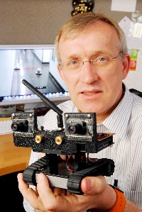
Henrik Christensen, a professor in the Georgia Tech College of Computing, holds a robotic vehicle (Gary Meek, Georgia Tech)
A team from Georgia Institute of Technology, University of Pennsylvania and California Institute of Technology/Jet Propulsion Laboratory (JPL) developed and demonstrated miniature vehicles that work by themselves to create a detailed floor plan of an office building. The researchers described their findings in a paper presented last month at the SPIE Defense, Security and Sensing Conference in Orlando, Florida.
The vehicles in the experiment worked independently with no input from human operators. Communicating only with one another, the vehicles divided up a variety of exploration tasks, rolled around the building floors making their observations and measurements, and created the office building floor plan. The only communications with human operators was delivery of the floor plan.
The ability to map and explore simultaneously was a milestone in the Micro Autonomous Systems and Technology (MAST) Collaborative Technology Alliance Program, a research initiative sponsored by the U.S. Army Research Laboratory. The vision of the program is for teams of small devices that can roll, hop, crawl, or fly just about anywhere, with sensors that detect and send back information to human operators.
The team’s experiment used robotic devices about one square foot in area, but the MAST project is aiming for even smaller devices that can be made in large quantities. The goal is to be able to deploy enough of these robotic devices to to work independently, and help humans scope out confined spaces or hazardous situations.
The MAST program involves four principal research teams: integration, microelectronics, microsystems mechanics, and processing for autonomous operation. The experiment combined navigation technology developed by Georgia Tech with vision-based techniques from JPL and network technology from the University of Pennsylvania.
The vehicles performed their mapping work with a video camera and a laser scanner, controlled by an onboard computer. The camera located doorways and windows, while the scanner measured walls. An inertial measurement unit helped stabilize the vehicle and provide information about its movement.
A graphing technique called simultaneous localization and mapping (SLAM) integrated the data from the video and laser sensors on the robot vehicles. SLAM allows an autonomous vehicle to develop a map of either known or unknown environments, while also monitoring and reporting on its own location. And SLAM can work either with or without GPS, which may not be able to reach the vehicles in battle environments or inside some buildings. The technology, however, enables the robots to keep track of their own locations as they move.
Upcoming capabilities for the vehicles include radar units to detect objects — including humans — behind walls, heat sensors, and sensitive whiskers that can sense the proximity of walls in the dark. The next experiment is expected to involve unmanned aerial surveillance to locate a building and its entry points, then calling in robotic mapping teams like those that took part in this experiment.
Read more: Institute Developing Autonomous Underwater Robots
* * *

 RSS - Posts
You must be logged in to post a comment.